info@dalmatiasibenik.hr
info@dalmatiasibenik.hr

A unique track immersed into extraordinarily beautiful countryside whose track profile enables pleasure of the ride and requires extreme skill and physical preparation. A race for all cyclist categories is organised on this track.
The first part of the route goes from the Krčić waterfall and the river Krka source hereunder to the hamlet of Kovačić where you get on the Napoleon road. You ride through the canyon of the river Krčić, overlooking Dinara, on the good macadam road with a light uphill incline. After 12.5 km you turn right to the uphill slope, the macadam road is not as good as the one on the first part and the elevation requires strength and skill. On the 15thkilometre you turn left to avoid the traffic road ride and you arrive to the hamlet of Bosnići where you soon turn right. There is a mild downhill part and from the 26th kilometre on, there is an extreme downhill part on poor macadam road and hairpin-bends that require great attention. You can see the river Krka and unique Colourful Lakes. What follows is the return to the starting point, the source of the Krka river under Krčić waterfall.
E - Easy track
M - Medium track
H - Heavy track
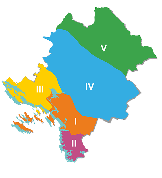
1. ZONA - ŠIBENIK (01 - 99) - Brodarica, Grebaštica, Zlarin, Žirje, Bilice
2. ZONA - PRIMOŠTEN - ROGOZNICA (101 - 199)
3. ZONA - VODICE (201 - 299) - Tribunj, Pirovac, Tisno, Betina, Jezera, Murter, Skradin
4. ZONA - DRNIŠ (301 - 399)
5. ZONA - KNIN (401 - 499)
With more than 2450 km of well-maintained routes in the region, you can enjoy the diverse offer – whether you want to cycle along the coast and enjoy the sea breeze, or take the countryside routes and get to know forest and mountain trails, vineyards and olive groves, or you want to experience high-adrenaline mountain trails and explore the canyons of the rivers Krka or Čikola, you can find all that and more in the Šibenik-Knin region.
Šibenik-Knin County Tourist board - TEL ++385 (0)22 219 072
Bike Club Faust Vrančić - GSM ++385 (0)91 254 26 76
BBK Orlovkrug 095 501 1111
MORE INFO