info@dalmatiasibenik.hr
info@dalmatiasibenik.hr
The track that leads through the history of this area since the prehistoric times. The starting point is in Skradin, following the slight uphill track towards the hamlet Skorići and then towards Bićine, under the highway towards the village of Prukljan at Prukljan Lake in the lower flow of the river Krka. Near the hamlet Prukljan the small river Guduča, interesting as a habitat of numerous bird species and due to this fact proclaimed an ornithological reserve, flows into the lake. The islet of Stipanac with the remains of ancient and medieval buildings known among people as Gavanovidvori is also in the vicinity. After that a mild uphill ride on the macadam road leads to the village of Sonković, a medieval fort of the noblemen of Sonković. Worth seeing is the archaeological site with the St. Marco’s Church, a protected cultural monument, as well as the new church of the Blessed AlojzijeStepinac. In Sonković there is the inexhaustible water spring mentioned even in records from the ancient times. Further on, the macadam track leads through the idyllic fields towards the village of Ždrapanj with the church of St. Bartholomew dating back from the 9th century; around the church there is a graveyard with the preserved standing tomb-stones, the early – Christian basilica and a villa rustica. Because of the archaeological value of the site, the whole area is under state protection.
The route leads through the field between the villages of Krković and Piramatovci. The village Krković is famous for its parish church of All Saints from the 13th century; at the site of Pećane there is a Palaeolithic cemetery and the remains of Neolithic settlement at the Vrbica site.
After that, on the 17th km, we get on the traffic road, then we ride for 2.8 km and then again we get off the traffic road to a macadam path towards the village of Bribir and the most important Croatian archaeological site BribirskaGlavica in which the continuity of the history of settlements since the Stone Age can be traced, through the Liburnian hill-fort, Roman Varvaria and the mighty fort of the Croatian feudal lords of Šubić in the 13th and 14th century.
We get on the asphalt road again towards the village of Vaćani in which the church of St. Anthony and the newly discovered old – Croatian cemetery can be visited. We continue towards Gračac, the field of Skradin and Skradin.
E - Easy track
M - Medium track
H - Heavy track
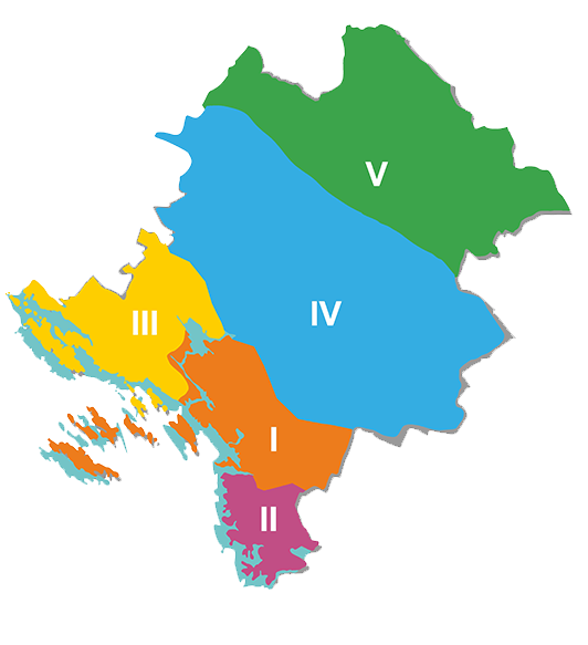
1. ZONA - ŠIBENIK (01 - 99) - Brodarica, Grebaštica, Zlarin, Žirje, Bilice
2. ZONA - PRIMOŠTEN - ROGOZNICA (101 - 199)
3. ZONA - VODICE (201 - 299) - Tribunj, Pirovac, Tisno, Betina, Jezera, Murter, Skradin
4. ZONA - DRNIŠ (301 - 399)
5. ZONA - KNIN (401 - 499)
With more than 2450 km of well-maintained routes in the region, you can enjoy the diverse offer – whether you want to cycle along the coast and enjoy the sea breeze, or take the countryside routes and get to know forest and mountain trails, vineyards and olive groves, or you want to experience high-adrenaline mountain trails and explore the canyons of the rivers Krka or Čikola, you can find all that and more in the Šibenik-Knin region.
Šibenik-Knin County Tourist board - TEL ++385 (0)22 219 072
Bike Club Faust Vrančić - GSM ++385 (0)91 254 26 76
BBK Orlovkrug 095 501 1111
MORE INFO