info@dalmatiasibenik.hr
info@dalmatiasibenik.hr

The track isn’t demanding but because of its length it requires a certain level of physical readiness. It starts from Primošten towards the hinterland of Primošten and it goes through the hamlets of Šarićevi and Luketini to the village of Široke. There is another mild uphill ride and after that the downhill ride towards the hamlet of Jurinovi, further to Prhovo and back to Primošten.
The track is exquisite because it goes through some of the prettiest olive groves and vineyards created in scarce and stone soil, bordered with kilometers of dry walls as monuments dedicated to diligent farmers of this area. The old traditional houses with roofs made of stone plates can be seen in the hamlets, and small stone shelters (“bunje”), puddles and stone wells, stone chapels and churches that look like a beautiful stone lace can be seen along the whole route.
E - Easy track
M - Medium track
H - Heavy track
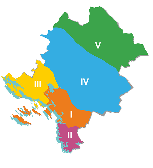
1. ZONA - ŠIBENIK (01 - 99) - Brodarica, Grebaštica, Zlarin, Žirje, Bilice
2. ZONA - PRIMOŠTEN - ROGOZNICA (101 - 199)
3. ZONA - VODICE (201 - 299) - Tribunj, Pirovac, Tisno, Betina, Jezera, Murter, Skradin
4. ZONA - DRNIŠ (301 - 399)
5. ZONA - KNIN (401 - 499)
With more than 2450 km of well-maintained routes in the region, you can enjoy the diverse offer – whether you want to cycle along the coast and enjoy the sea breeze, or take the countryside routes and get to know forest and mountain trails, vineyards and olive groves, or you want to experience high-adrenaline mountain trails and explore the canyons of the rivers Krka or Čikola, you can find all that and more in the Šibenik-Knin region.
Šibenik-Knin County Tourist board - TEL ++385 (0)22 219 072
Bike Club Faust Vrančić - GSM ++385 (0)91 254 26 76
BBK Orlovkrug 095 501 1111
MORE INFO